
Saltar al contenido principal

Mineral intelligence

Angola mineral map

Documented mineral occurrences and deposits, with the source, date and precision of every record. Geological evidence is kept apart from mining rights.

How to read this map

  • Geology, not mining rights

    Points are occurrences and deposits reported by public sources. No concession, licence or holder is shown, and none is inferred.

  • A partial public edition

    28 records from 3 USGS compilations. The official IGEO/BADAGEO vectors are not part of this edition, so Angola’s national inventory is not represented.

  • Precision as published

    Coordinates are the source’s own, with no survey-grade accuracy. Snapshot of 10 October 2026.

Interactive map of mineral records in Angola

21 locations · 28 records

Filter by mineral all minerals
Mineral

Select one or more. With none selected, all minerals show.

Layers and data availability 3 of 3 evidence layers
Geological evidence

Reference

Not loaded

Part of the data model, but the source data is not available to this project. Listed so that their absence is visible.

  • IGEO / BADAGEO occurrences Geology · not loaded Original vectors not yet received from IGEO. This is the main gap: the USGS layers above are corroboration, not the national inventory.
  • Mining rights and concessions Legal rights · not loaded No official CMA/ANRM export is available. No concession is shown, and none is inferred from geology.
  • Named in the USGS major-deposit compilation
  • USGS critical-minerals compilation only
  • Historical USGS record only

Public USGS evidence, snapshot of 10 October 2026. This map shows geology, not mining rights. Sources and precision · Coverage gaps

Traceability

Sources and precision

Every record keeps its source, date, scale and coordinate system. Geological evidence and legal mining rights are separate layers and are never inferred from one another.

What this map can say

  • “This source reports a mineral occurrence or deposit at this location.”
  • “This publication defines a prospectivity area at this scale.” (none loaded yet)
  • “The official cadastre records a mining title.” (none loaded yet)

What it must not be read as

  • A reserve or resource estimate.
  • Proof that a historical mine operates today.
  • A record of concessions or licence holders.
  • Survey-grade coordinates, or a complete inventory of Angola.

Order of authority

  1. IGEO / BADAGEO / PLANAGEO for geology.
  2. CMA / ANRM for current mining rights.
  3. PLANAGEO 1:50,000 studies over older 1:1,000,000 mapping.
  4. USGS layers as corroboration only.

On the map

Snapshot retrieved 10 October 2026. The site does not query these services when you visit: the data is a reviewed copy.

USGS-MAJOR-2005 On the map

Major mineral deposits (global compilation, OFR 2005-1294)

U.S. Geological Survey (USGS)

Named major deposits. Corroboration only: it is neither a current inventory nor a mining-rights register.

Date
2005 compilation; source records may be older
Scale / accuracy
Point; record-level latitude/longitude, accuracy not stated
Coordinate system
EPSG:4326
Coverage
Global synthesis of major deposits; not exhaustive for Angola.
Precision
Coordinates are as published (typically 4–5 decimals). USGS states no positional accuracy; treat as site-level orientation, not survey grade.
Licence
USGS public data (U.S. Government work); credit USGS.
Records
13 returned by the service · 13 inside Angola and shown
USGS-CRITICAL-2017 On the map

Global distribution of selected mines, deposits and districts of critical minerals

U.S. Geological Survey (USGS)

Selected critical-mineral sites. By design it covers selected commodities only.

Date
2017 data release
Scale / accuracy
Point/polygon global compilation; this map uses the point layer
Coordinate system
EPSG:4326
Coverage
Selected critical minerals only; two Angolan records.
Precision
Approximate named-site locations. One record (Lueca) sits about 185 km from the USGS major-deposit and MRDS records of the same name; they are not merged.
Licence
USGS data release. Reuse terms are stated on the release page (see Metadata); credit USGS.
Records
2 returned by the service · 2 inside Angola and shown
USGS-MRDS On the map

Mineral Resources Data System (MRDS), compact point layer

U.S. Geological Survey (USGS)

Historical occurrence evidence. Status fields (producer, prospect…) are legacy and not current.

Date
Legacy compilation; USGS ceased systematic updates in 2011; record dates vary
Scale / accuracy
Point; positional accuracy varies by record
Coordinate system
EPSG:3857 at source, requested as EPSG:4326
Coverage
USGS itself states that coverage outside the United States is incomplete.
Precision
Full records may state a location accuracy (for example 1,000 m); the compact layer used here does not carry it, so none is shown. The A–E grade is record completeness, not ore grade.
Licence
USGS public data (U.S. Government work); credit USGS.
Records
29 returned by the service · 13 inside Angola and shown
AO-DPA-2024-ARCGIS On the map

Nova Divisão Administrativa de Angola — Províncias

ArcGIS Online contributor; described as based on Diário da República, Lei n.º 14/24

Outline for orientation, to assign a province to each record and to discard records that fall outside Angola. Not a legal or cadastral boundary.

Date
2024
Scale / accuracy
Administrative polygons; no survey accuracy stated
Coordinate system
EPSG:3857 at source, requested as EPSG:4326
Coverage
All 21 provinces of Lei n.º 14/24.
Precision
Clipping used the full-resolution polygons; the outlines drawn here are simplified (about 1 km). A province shown for a record within 3 km of a boundary is indicative only.
Licence
Not stated by the publisher. Replace with official IGEO/INE boundaries before treating as final.
16 USGS records were left out because they are not in Angola

The USGS query is by rectangle, so it also returns neighbouring countries. Each record below falls outside every 2024 province polygon, and the USGS record itself states a different country.

RecordLocation stated by USGSDistance to nearest Angolan province
Kisenge USGS-MRDS:10106135 Kisenge Past Producer in Katanga, Congo (Kinshasa) 38.6 km
Chisamba USGS-MRDS:10158691 Chisamba Unknown in North-Western, Zambia 8.7 km
Kisenge USGS-MRDS:10159211 Kisenge Producer in Katanga, Congo (Kinshasa) 29.5 km
Holle St. Paul USGS-MRDS:10231861 Holle St. Paul Plant in Congo (Brazzaville) 23.9 km
Sumbi USGS-MRDS:10280827 Sumbi Prospect in Congo (Kinshasa) 49.4 km
Adumbi USGS-MRDS:10304520 Adumbi Prospect in Congo (Kinshasa) 174.5 km
Romano USGS-MRDS:10003780 Romano Occurrence in Congo (Brazzaville) 1.9 km
Ganda Binda USGS-MRDS:10003781 Ganda Binda Occurrence in Congo (Brazzaville) 1.1 km
Londela-Kayes USGS-MRDS:10003782 Londela-Kayes Occurrence in Congo (Brazzaville) 36.4 km
M'Passa Mine USGS-MRDS:10008200 M'Passa Mine Producer in Congo (Brazzaville) 121.6 km
Mfuati Pb Mine USGS-MRDS:10093688 Mfuati Pb Mine Occurrence in Congo (Brazzaville) 178.3 km
M'Fouati USGS-MRDS:10134601 M'Fouati Producer in Congo (Brazzaville) 84 km
Twangiza USGS-MRDS:10304448 Twangiza Prospect in Congo (Kinshasa) 174.5 km
Kaluwa USGS-MRDS:10134907 Kaluwa Prospect in Western, Zambia 116.3 km
Mulozi Prospect USGS-MRDS:10256276 Mulozi Prospect Occurrence in Western, Zambia 130.3 km
Monts Bamba USGS-MRDS:10003783 Monts Bamba Occurrence in Congo (Brazzaville) 61.1 km

Authoritative sources not yet available

These are the sources that should govern this map. They are named here so that their absence is visible; nothing on the map stands in for them.

AO-IGEO-PLANAGEO-BADAGEO Not loaded

BADAGEO national geological database and PLANAGEO deliverables

Instituto Geológico de Angola (IGEO) / PLANAGEO

Preferred production source for mineral occurrences, geology and prospectivity. Not available to this project yet: no vector layer has been received.

Date
PLANAGEO 2014–2022; BADAGEO continuously updated
Intended scale
Regional 1:250,000; selected detailed studies 1:50,000
Licence
Access and reuse terms to be confirmed with IGEO.
AO-CMA Not loaded

Cadastro Mineiro Digital de Angola (CMA)

MIREMPET / ANRM / IGEO

The only valid source for current mining titles: holder, status, validity and concession polygons. No stable public GIS endpoint has been verified, so no mining right is shown.

Date
Current implementation (public presentation 2025)
Intended scale
Concession polygons and title attributes when exported by the official portal
Licence
Service and export terms to be confirmed with ANRM/CMA.

Reference and literature

Cited for context and cross-checking. No coordinate on the map is taken from them.

  • Mapa de ocorrências minerais de Angola Government of Angola / Instituto Geológico de Angola (IGEO) · 2021-11-02 (date printed on the map)

    Authoritative visual reference. It is a raster and is deliberately not traced into coordinates.

    Scale
    National overview raster
    Precision
    Symbol positions are overview-scale; not suitable for licence or site-boundary decisions.
    Licence
    Government publication; reuse rights not stated on the page. Shown with attribution on News & Insights.
  • Lei n.º 14/24, Divisão Político-Administrativa República de Angola — Diário da República · 2024-09-05

    Legal validation of the administrative structure (21 provinces, 326 municipalities, 378 communes).

    Scale
    Legal text
    Precision
    Validates names and counts; it is not a GIS layer.
    Licence
    Official gazette.
  • ANRM public portal — mining-rights statistics Agência Nacional de Recursos Minerais (ANRM) · Current statistics; the portal shows its own update date

    Current statistics on mining rights. No geometry is taken from it.

    Scale
    National/provincial statistics
    Precision
    Not applicable.
    Licence
    Government portal; reuse terms not stated.
  • Anuário do Sector dos Recursos Minerais, Petróleo e Gás 2024 MIREMPET · 2024

    Official programme status, including BADAGEO updating and survey scales.

    Scale
    Report
    Precision
    Not applicable.
    Licence
    Government publication.
  • Angola — mineral industry country page and annual reporting USGS National Minerals Information Center · 2024 data

    National production and facility statistics. No coordinate is taken from its tables.

    Scale
    National statistics
    Precision
    Not applicable.
    Licence
    USGS public information.
  • UTE-PLANAGEO (Plan Nacional de Geología de Angola): objectives, methods and results IGME-CSIC, LNEG, UTE-PLANAGEO and IGEO contributors — Boletín Geológico y Minero 136(1), 2025 · 2025

    Modern 1:50,000 metallic-mineral studies (Au–Fe, REE, Cr-Ni-PGE/Cu/Nb-Ta-Be). Cross-check and gap evidence.

    Scale
    1:50,000 detailed studies; 1:250,000 regional
    Precision
    Not applicable: no geometry is taken from the publication.
    Licence
    Publication terms apply.
  • Preliminary Metallogenetic Map of Southern Angola, 1:1,000,000 LNEG / IGME-CSIC / PLANAGEO partners · 2024

    Regional metallogenic framework; scientific cross-check.

    Scale
    1:1,000,000
    Precision
    Regional synthesis, not site scale.
    Licence
    Repository terms apply.
  • Au–Fe mineral prospectivity in southern Angola LNEG / PLANAGEO partners · 2024

    Evidence for detailed Au–Fe targets in selected southern areas.

    Scale
    Underlying mapping 1:50,000
    Precision
    Not applicable.
    Licence
    Repository terms apply.
  • CARMINA — industrial rocks and minerals cartographic series LNEG / PLANAGEO partners · 2024

    Reference for industrial minerals, which global databases under-represent.

    Scale
    Varies by sheet
    Precision
    Varies by sheet.
    Licence
    Repository terms apply.
  • Carta de Recursos Minerais de Angola Instituto Geológico de Angola · 1998

    Foundational national mineral-resource map behind most later summaries (named areas in the coverage section).

    Scale
    1:1,000,000 (four sheets)
    Precision
    Historical synthesis; not a current legal or operational dataset.
    Licence
    Bibliographic record only.
  • WEBSIG NW-Angola — reproduction and summary of the 1998 map Universidade Nova de Lisboa (thesis, 2015), reproducing IGEO 1998 · 2015 (reproducing 1998)

    Secondary source for the named mineralisation areas in the NW (Maiombe, Dande, Mavoio–Tetelo…).

    Scale
    National map reproduction
    Precision
    Secondary reproduction: the original IGEO map outranks it.
    Licence
    Academic repository terms apply.

Known limits

Coverage gaps

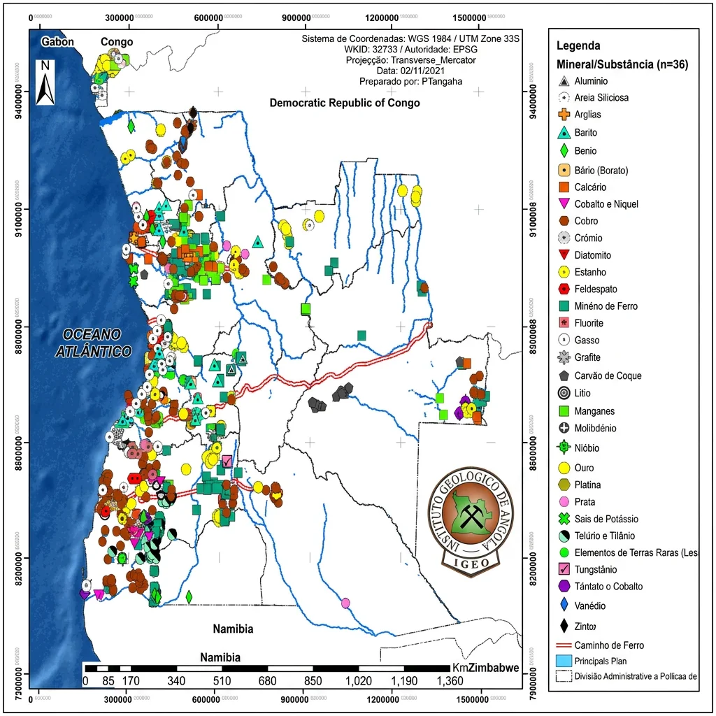
The Government of Angola’s 2021 mineral-occurrence map distinguishes far more classes and areas than the three public USGS compilations behind this edition. The gap is structural, not a handful of missing markers. A location absent from the map is not evidence that nothing is there.

Map of Angola plotting recorded occurrences of 36 mineral substances — including gold, copper, iron ore, manganese, tin and rare-earth elements — over provincial boundaries, the main rivers and the railway lines, with the Atlantic coast to the west. The legend is in Portuguese.

Geological cartography by the Instituto Geológico de Angola (IGEO), reproduced with express attribution of authorship. Rights remain with the author.

Open the full-size map

The official reference

The Instituto Geológico de Angola maintains the national inventory of mineral occurrences: 36 substances plotted against provincial boundaries, the main river systems and the railway network. Its legend is the benchmark for the table below.

It is a raster, so it is shown for comparison and is deliberately not traced into coordinates. Edition of 2 November 2021 · WGS 1984 / UTM Zone 33S.

Legend of the official map, against this edition

The map above prints 36 substances; 32 are legible in this reproduction and 4 fall outside the frame. This edition has records for 9 of those 32. Entries are shown as printed, including spelling errors.

Legend entries of the official IGEO map and their coverage in this edition
Printed on the official map Reading Records in this edition
Aluminio Aluminum 1 record · 1 location (Aluminum)
Areia Siliciosa Silica sand Silica appears in this edition only as a secondary commodity of iron prospects. None in this edition
Argilas Clays None in this edition
Barito Barite None in this edition
Benio Unclear as printed None in this edition
Bário (Borato) Barium (borate) None in this edition
Calcário Limestone None in this edition
Cobalto e Níquel Cobalt and nickel None in this edition
Cobre Copper 5 records · 3 locations (Copper)
Crómio Chromium None in this edition
Diatomito Diatomite None in this edition
Estanho Tin None in this edition
Feldspato Feldspar None in this edition
Minério de Ferro Iron ore 9 records · 5 locations (Iron)
Fluorite Fluorite None in this edition
Gasso Unclear as printed None in this edition
Grafite Graphite None in this edition
Carvão de Coque Coking coal None in this edition
Litio Lithium None in this edition
Manganes Manganese None in this edition
Molibdénio Molybdenum None in this edition
Nióbio Niobium 1 record · 1 location (Niobium)
Ouro Gold 1 record · 1 location (Gold)
Platina Platinum None in this edition
Prata Silver 1 record · 1 location (Silver)
Sais de Potássio Potassium salts None in this edition
Telúrio e Tilânio Tellurium and titanium “Tilânio” is printed so; read as titanium. 3 records · 3 locations (Titanium)
Elementos de Terras Raras (Les… Rare-earth elements The label is cut off in the reproduction. None in this edition
Tungstânio Tungsten None in this edition
Tântato o Cobalto Tantalum and cobalt Printed so; read as tantalum and cobalt. 1 record · 1 location (Tantalum)
Vanédio Vanadium “Vanédio” is printed so; read as vanadium. 5 records · 4 locations (Vanadium)
Zinto Zinc “Zinto” is printed so; read as zinc. None in this edition

“Records in this edition” counts exact commodity matches only. It is not a measure of completeness: the official map plots hundreds of occurrences, this edition 28. Commodities here that are not among the legible legend entries: Diamond, Lead, Phosphate, Silica, Sulfur, Uranium.

Named areas to represent, without coordinates

These areas are described in literature attributed to IGEO and PLANAGEO. They are listed so that they are accounted for; no position has been invented for them and none is drawn on the map.

Zaire

  • Noqui — Muscovite occurrence
  • Coluje-Tando — Phosphorite

Source: AO-IGEO-1998-SCAN

Bengo / Luanda / NW Kwanza basin

  • Dande region — Muscovite, feldspar, kaolin and beryllium occurrences
  • Caxito–Úcua — Ornamental rocks (gneiss, schist)
  • Libongos–Cachoeiras — Asphaltite and copper potential
  • Luanda region — Sodium and gypsum potential

Source: AO-IGEO-1998-SCAN

Uíge / Western Congo aulacogen

  • Mavoio–Tetelo — Copper; lead, zinc, gold, iron and vanadium also reported in the historical literature
  • Quitexe — Titanium and copper; iron and marble also reported

Source: AO-IGEO-1998-SCAN

Huíla and adjacent southern areas

  • Cassinga / Jamba — Major iron district
  • M’Popo — Gold
  • Navondira / Chipindo — Gold occurrence
  • Cuíma-Samboto, Chipindo, Jamba, M’Popo-Tchamutete — PLANAGEO 1:50,000 Au–Fe study areas
  • Humpata, Chibía–Hamutenha — PLANAGEO Cr-Ni-(PGE), Cu and Nb-Ta-Be study clusters
  • Tchivira–Bonga — PLANAGEO REE / Nb-Ta study area

Sources: AO-IGEO-1998-CRM, AO-PLANAGEO-CRMMA-2025

Namibe

  • Giraúl — PLANAGEO Cr-Ni-(PGE), Cu and Nb-Ta-Be study area
  • Serra da Neve — PLANAGEO REE study area
  • Bero–Giraúl area — Gypsum occurrences
  • Iona — Mica occurrence

Sources: AO-PLANAGEO-CRMMA-2025, AO-IGEO-1998-CRM

Cuanza Sul / Benguela coastal belt

  • Sumbe — Gypsum
  • Lobito / Benguela — Gypsum
  • Gungo — Mica
  • Praia de Mandongal — Mica

Source: AO-IGEO-1998-CRM

Quiçama / Kwanza sedimentary area

  • Morro Tuenza — Rock salt
  • Sanza — Rock salt

Source: AO-IGEO-1998-CRM

Lunda Norte / Lunda Sul / Malanje

  • Northeast diamond province — Extensive kimberlite and alluvial-diamond significance. Operating status is a mining-rights question and is not inferred here.

Sources: AO-GOV-IGEO-2021, AO-IGEO-1998-CRM

Modern studies that should replace the legacy detail

PLANAGEO produced detailed 1:50,000 studies that should take precedence over symbols read from a 1:1,000,000 national raster.

  • Au–Fe: Cuíma-Samboto, Chipindo, Jamba, M’Popo-Tchamutete
  • REE: Catanda, Serra da Neve, Tchivira-Bonga
  • Cr-Ni-(PGE), Cu, Nb-Ta-Be: Giraúl, Humpata, Chibía-Hamutenha

What would close the gap

An official data package from IGEO and ANRM, with documented reuse terms:

  • BADAGEO mineral-occurrence vectors, with record ID and classification
  • Geological map units and structures at the intended display scale
  • PLANAGEO metallogenic and prospectivity layers, where publication is authorised
  • Current CMA title polygons with holder, commodity, status and dates
  • Official current administrative boundaries
  • Full metadata: CRS, scale, lineage, positional accuracy, update date and reuse terms